LEAKED photos of Iron Man 3 villain – the colorful armor of Iron Patriot with actor James Badge Dale.

LEAKED photos of Iron Man 3 Villain: Iron Patriot

James Badge Dale (“The Departed,” TV’s “24”) is seen here as Iron Patriot or with his character’s name: Eric Savin, one of the villains of “Iron Man 3.” In the comics, Savin is a soldier who is gravely injured in a land mine explosion and reanimated as a cyborg called Coldblood-7. It looks like the movie merges his character from the books with the Iron Patriot armor (which was worn by Spider-Man’s nemesis Norman Osborn, aka the Green Goblin).
LEAKED photos of Iron Man 3 Villain: Iron Patriot
Related Posts
 Cat Hug Pics and Kitty Cuddle Cat Pictures
 The Deadliest Cars in the World: Most Dangerous Vehicles EVER
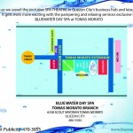 Blogger Event – BlueWater Day Spa Ribbon Cutting with Karylle
 NCAA Basketball Tournament: Big Weekend for Bubble Teams
 SEO Tips: Keywords How to Be on Top of Google Searches
 Why am I GREAT?
 “Niche Dominators: Success Secrets Exposed” book launch & preview
 WhenInManila.com launched!
  Win P100k and a Vacation Getaway from Thunderbird Resorts
 I’m the Medicol Advance “Blogger of the Month!”
 LOL Cats Try to Understand Treadmill
 Chalk Magazine: “10 Bright Young Manila” featuring FlairCandy